Real-Time System State Prediction & Optimal Rebalancing Strategies for Public Bike Sharing Systems
Sponsor: Mid-Atlantic Transportation Sustainability Center – Region 3 University Transportation Center
Fund: $160,000
PI: Rajesh Paleti, Ph.D.
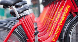
Many cities in the nation are making investments in innovative public transportation infrastructure such as Bicycle Sharing Systems (BSS). These systems are recognized to have traffic and health benefits including flexible mobility, physical activity, and support for multimodal transport connections. However, BSS research in the transportation field is still in its infancy. For instance, one key recurring problem that BSS operators deal with is rebalancing of bikes at regular intervals to redistribute bikes from full stations to empty stations to meet the expected demand patterns. Currently, rebalancing schedules are either based on historical trends or simple heuristics (e.g., all stations must be half empty). However, optimal rebalancing strategies that minimize the disutility associated with not finding a bike or an empty slot are missing. This problem can be addressed by drawing strength from BSS digital data portals that provide large streams of real time system state data. The primary goal of this study is to develop tools that can be used to enhance the performance of BSS, in particular the Capital Bikeshare. Capital Bikeshare is one of the oldest and largest BSS operating in Washington D.C., Virginia, and Maryland. In this context, the objectives of the study are three-fold:
Objective (1): Develop real-time system state prediction models of BSS. These models will be able to predict the number of departures of customers for retrieving bikes and number of arrivals of customers for returning bikes at each station by time-of-day.
Objective (2): Develop heuristic algorithms for managing the expected demand patterns. This includes development of quick heuristic algorithms that can identify optimal rebalancing schedules as demand evolves in real-time
Objective (3): Integrate the predictive models into a GIS toolkit with an easy-to-use Graphical User Interface (GUI) that visually depicts the future demand patterns (for BSS customers) and associated optimal rebalancing routes and schedules (for BSS operators).
Fund: $160,000
PI: Rajesh Paleti, Ph.D.
Many cities in the nation are making investments in innovative public transportation infrastructure such as Bicycle Sharing Systems (BSS). These systems are recognized to have traffic and health benefits including flexible mobility, physical activity, and support for multimodal transport connections. However, BSS research in the transportation field is still in its infancy. For instance, one key recurring problem that BSS operators deal with is rebalancing of bikes at regular intervals to redistribute bikes from full stations to empty stations to meet the expected demand patterns. Currently, rebalancing schedules are either based on historical trends or simple heuristics (e.g., all stations must be half empty). However, optimal rebalancing strategies that minimize the disutility associated with not finding a bike or an empty slot are missing. This problem can be addressed by drawing strength from BSS digital data portals that provide large streams of real time system state data. The primary goal of this study is to develop tools that can be used to enhance the performance of BSS, in particular the Capital Bikeshare. Capital Bikeshare is one of the oldest and largest BSS operating in Washington D.C., Virginia, and Maryland. In this context, the objectives of the study are three-fold:
Objective (1): Develop real-time system state prediction models of BSS. These models will be able to predict the number of departures of customers for retrieving bikes and number of arrivals of customers for returning bikes at each station by time-of-day.
Objective (2): Develop heuristic algorithms for managing the expected demand patterns. This includes development of quick heuristic algorithms that can identify optimal rebalancing schedules as demand evolves in real-time
Objective (3): Integrate the predictive models into a GIS toolkit with an easy-to-use Graphical User Interface (GUI) that visually depicts the future demand patterns (for BSS customers) and associated optimal rebalancing routes and schedules (for BSS operators).
Smartphone-Based Solutions to Monitor and Reduce Fuel Consumption and CO2 Footprint
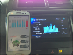
Sponsor: TranLIVE Tier-I University Transportation Center/USDOT
Fund: $150,000
PI: Mecit Cetin, Ph.D.
Description: Our research team is developing innovative models to estimate carbon footprint for a multi-modal trip using data generated by motion sensors within a smartphone. Research is underway to estimate the mode of travel and operating mode of a vehicle (e.g., idling, accelerating) based on low-energy sensors (e.g., gyroscope, compass, and accelerometer) available within all smartphones. Even though researchers used cell phones for trajectory estimation before, these relied on GPS which has the disadvantages of low accuracy in urban canyons and depleting the phone battery quickly. The team will also estimate carbon footprint for a multi-modal trip and develop a smartphone application. An application will be developed to automatically detect the traveler’s mode of transportation (walking, biking, train, car, bus, etc.) and compute the CO2 emissions. The user will receive feedback for each trip completed so that he/she can make more informed choices about mode, route, and departure time options.
LiDAR for Air Quality Measurement
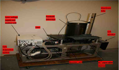
Sponsor: MATS UTC/USDOT
PI: Khan M. Iftekharuddin PhD, CoPIs: Mecit Cetin, Ph.D. and Hesham Rakha, PhD
Description: The overall goal of this research is to investigate a unique LiDAR (light detection and ranging) technology for ambient air quality measurement of particulate matter (PM). The ODU team has recently received a state‐of‐the‐art elastic LiDAR from NASA Langley Research Center developed to measure aerosol vertical profiles. Originally designed to be mounted on an aircraft, this compact, portable, airborne LiDAR was used in several field studies, e.g., California Central Valley and Hampton Roads, for measuring PM distribution over a geographic area under the flight path. However, this sophisticated LiDAR can also be used on the ground (shooting the laser beam into atmosphere) to measure PM in the air related to vehicle emission. In addition, the system can also be mounted on ground vehicles to move around hot‐spots (e.g., ports, entrance to tunnels etc.) to measure specific vehicle emission related pollutants such as PM. The current LiDAR is capable to detecting several different pollutant particles including PM in the atmosphere. However, specific enhancement to the LiDAR hardware is necessary to make it sensitive to PM classification. Therefore, the specific goals of this research include:
- Enhance the capabilities of the LiDAR system to detect smoke and soot emitted from the vehicle emissions that are related to particulate material (PM)
- Investigate correlation between measured PM concentration over a large area and traffic flow patterns
- Incorporate measured air quality data from LiDAR into GIS and accurately identify the locations of high pollution areas adversely affected due to operation of diesel engines (e.g., ports, chokepoints etc.)
Reducing Energy Use and Emissions through Innovative Technologies and Community Designs: Methodology and Application in Virginia
Sponsor: Commonwealth Research Commercialization Fund (CRCF)
Fund: $100,000
PI: Mecit Cetin, Ph.D.
Description: Traffic incidents are the cause of 50% to 60% of the traffic congestion on major roadways in urban areas. Emissions from idling vehicles delayed by incidents are typically more than double the normal level. Moreover, secondary incidents can complicate the task of clearing a primary incident. This project aims to develop and commercialize an incident management and early warning software tool. The tool can be used by cities, counties, and state agencies to help them with effective solutions to mitigate the negative effects of freeway incidents, traffic delays, and consequent emissions. The overall goal is enhancing livability and sustainability in urban areas. The project will encourage the consideration, evaluation and implementation of eco-friendly transportation strategies.
Investigating the Vulnerability of the Transportation Infrastructure in Hampton Roads Region to Extreme Weather and Sea Level Rise
Sponsor: Virginia Department of Transportation (VDOT) - Cost share project for MATS UTC
PI: Dr. Navid Tahvildari, CoPI: Dr. Mecit Cetin
Description: The most common way of studying the impacts of Sea Level Rise (SLR) and storm surge on urban areas is to increase the surface water elevation and compare the new sea level with topographic elevations. Recent work in Hampton Roads has used this simple “bathtub” model to investigate the impact to transportation infrastructure in Norfolk and Virginia Beach due to SLR and storm surge. This approach neglects the dynamic nature of storm surges, waves, tides, and overland flow, and the interactions between these processes and natural and urbanized landscape. These processes can be captured in a hydrodynamic model. In this project, we propose to develop a hydrodynamic model based on the widely used ADCIRC+SWAN model for Hampton Roads, VA. The model will be calibrated and validated with site-specific data that will be obtained from the municipalities in the region. The results will include time-series of inundation depth for three sea level scenarios (present, medium SLR, and high SLR) at high spatial resolution over the entire domain of the study. In consultation with Virginia Department of Transportation (VDOT) and the City of Norfolk, we have identified several critical locations for vulnerability analysis. The critical spots in Norfolk were identified based on frequent flooding issues, traffic volumes, and the access they provide to critical points in the City, specifically the Naval base and Norfolk’s General Hospital (which houses the region’s only trauma center). VDOT also identified two location that are significant as they are located at two critical water crossings and impact substantial traffic volumes. Accurate prediction of the time and duration of flooding at these areas will help VDOT with advanced warnings and rerouting of traffic. The modelling framework, once developed, can be utilized to assess the flood damage mitigation and the effectiveness of adaptation measures proposed for the region. The model will be run at higher resolution and detailed maps of inundation depth and duration will be developed for these critical spots.